

- 简
- 繁
- En

Observatory will issue Standby Signal No.1 tomorrow morning
發佈: 2026-07-01 12:55
撰文: 無綫新聞


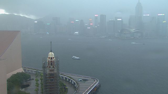
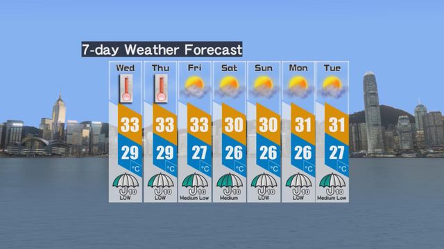
The area of low pressure over the central and southern parts of the South China Sea has intensified into a tropical depression. It is expected to enter within 800 kilometres of Hong Kong later today.
The Observatory will issue the Standby Signal, No.1 tomorrow morning (2 July). The tropical cyclone is expected to move in the general direction of the vicinity of Hainan Island to Beibu Wan tomorrow and on Friday (2 and 3 July).
It will maintain a distance of 400 kilometres or more from Hong Kong. Under its influence, local winds will strengthen on Friday and weather will become unsettled. There will be swells. Squally showers will increase gradually, and showers will be heavier in some areas.
Due to the effect of terrain, gale force winds may affect parts of high ground. With the tropical cyclone making landfall over the western coast of southern China during the weekend, local weather will be dominated by an active southerly airstream gradually.
It will still be windy with occasional showers and squally thunderstorms. Members of the public should take note of the latest weather information from the Observatory. When engaging in outdoor activities, especially water sports, please be aware of the change in weather and pay attention to safety at all times.
更多新聞

Amber rainstorm signal issued during early morning


Very Hot Weather and Thunderstorm Warnings both in force

Helpline sees surge in seniors suffernig in stifling homes


熱門新聞


條款及細則
條款及細則
隨時隨地觀看新聞,立即下載

'%3e%3cpath%20id='路径_2'%20data-name='路径%202'%20d='M579.91,145.916a42.433,42.433,0,1,0,42.528,42.433,41.772,41.772,0,0,0-42.528-42.433m0,68.138a25.8,25.8,0,1,1,23.91-25.705,24.572,24.572,0,0,1-23.91,25.705m-92.9-68.138a42.433,42.433,0,1,0,42.528,42.433,41.772,41.772,0,0,0-42.528-42.433m0,68.138a25.8,25.8,0,1,1,23.911-25.705,24.572,24.572,0,0,1-23.911,25.705m-110.38-55.1v17.956h42.621A37.793,37.793,0,0,1,409.8,199.6a44.037,44.037,0,0,1-33.266,13.135,47.914,47.914,0,0,1,0-95.734,45.836,45.836,0,0,1,32.415,12.854l12.664-12.664a62.75,62.75,0,0,0-45.174-18.144,66.153,66.153,0,1,0,0,131.739,60.2,60.2,0,0,0,45.93-18.9A59.452,59.452,0,0,0,438.154,170.2a58.644,58.644,0,0,0-.946-11.246Zm451.638,14.364a39.409,39.409,0,0,0-36.291-26.933A40.259,40.259,0,0,0,752,188.822a41.49,41.49,0,0,0,42.055,42.432,42.148,42.148,0,0,0,35.344-18.9l-14.459-9.45a24.193,24.193,0,0,1-20.885,11.718,21.546,21.546,0,0,1-20.6-12.852l56.7-23.436ZM770.431,187.5a23.249,23.249,0,0,1,22.21-24.76,16.441,16.441,0,0,1,15.781,9.45Zm-46.023,40.637h18.9V103.577h-18.9Zm-30.525-72.77h-.568a29.385,29.385,0,0,0-22.3-9.449,42.526,42.526,0,0,0,0,85.053,28.908,28.908,0,0,0,22.3-9.449h.663v6.142c0,16.256-8.7,24.854-22.681,24.854a23.431,23.431,0,0,1-21.358-15.12l-16.255,6.71a40.446,40.446,0,0,0,37.8,25.044c21.829,0,40.354-12.853,40.354-44.134V148.468H693.883Zm-21.359,58.594A24.381,24.381,0,0,1,648.9,188.443a24.57,24.57,0,0,1,23.625-25.894,23.909,23.909,0,0,1,22.682,25.894,23.722,23.722,0,0,1-22.682,25.611ZM915.592,103.484H870.985V228.135h18.9V180.883h25.988a38.747,38.747,0,1,0,0-77.4Zm.471,60.1H889.6V120.872h26.461a21.358,21.358,0,1,1,0,42.715m115.012-17.861a34.97,34.97,0,0,0-33.171,18.9l16.539,6.9a17.583,17.583,0,0,1,17.01-9.452,17.958,17.958,0,0,1,19.564,16.066v1.324a41.193,41.193,0,0,0-19.373-4.819c-17.767,0-35.913,9.449-35.913,28.35a28.352,28.352,0,0,0,30.9,27.407,26.277,26.277,0,0,0,23.722-12.191h.661v9.45h17.956v-47.44c-.095-22.115-16.539-34.5-37.9-34.5m-2.268,68.328c-6.047,0-14.552-3.024-14.552-10.585,0-9.45,10.583-13.325,19.751-13.325a33.169,33.169,0,0,1,17.011,4.159,22.588,22.588,0,0,1-22.21,19.751m105.468-65.586-21.357,54.057h-.663l-22.02-54.057H1070.2l33.172,75.6-18.9,42.054h19.374l51.128-117.563ZM966.718,228.135h18.9V103.577h-18.9Zm-840.431-101.5L4.377,4.631A20.131,20.131,0,0,0,.029,18.24V238.72a21.079,21.079,0,0,0,3.4,12.569Zm4.064-3.876,37.8-37.8L25.356,3.214A18.9,18.9,0,0,0,8.912.945Zm89.4-8.695L172.5,87.417l-38.652,39.221,41.3,41.3L219.28,142.8c14.46-7.844,14.46-20.791.472-28.73m-89.4,16.539L7.495,254.974a17.768,17.768,0,0,0,17.768-1.607l144.686-82.219h.566Z'%20fill='%23fff'/%3e%3c/g%3e%3c/svg%3e)


Copyright 2026 Television Broadcasts Limited