
繁

- 简
- 繁
- En

Unsettled weather in Hong Kong after scorching heat
News
發佈: 2026-06-06 20:03
撰文: 無綫新聞


The Amber Rainstorm Signal is in force. The Observatory says a broad trough of low pressure will continue to bring unsettled weather to the territory in the following couple of days.
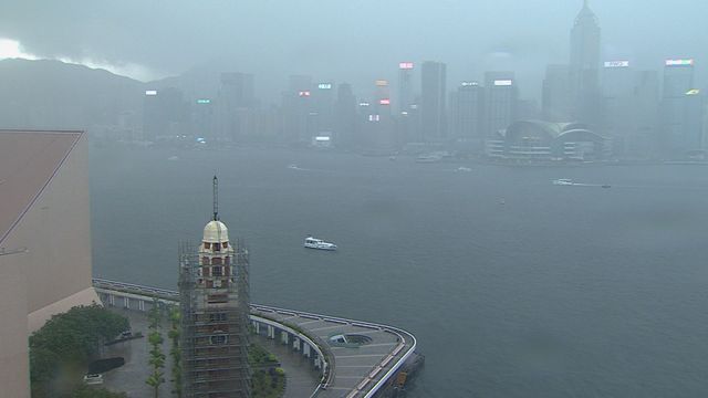
An overcast sky. After several days of scorching heat, Hong Kong manages to cool down, thanks to some strong showers.
At 10 a.m., the Observatory issued the Amber Rainstorm Signal. In Central, some passersby take shelter under a cover.
Weather authorities say that a broad trough of low pressure is bringing showers and thunderstorms to the coast of Guangdong.
Some areas recorded more than 20 millimetres of rainfall in the morning, whereas the precipitation exceeded 40 millimetres in parts of Sai Kung and the northern part of the New Territories.
The amber signal stayed for 90 minutes in the morning, and was
issued again early this evening.
Looking ahead, the Observatory forecasts heavy showers and squally thunderstorms will continue to affect Hong Kong until Tuesday and reminds residents to be aware of the change in weather before heading out.
Extreme weather is becoming more apparent around the world. According to the World Meteorological Organisation, an El Nino event is likely to happen between June and August.
A meteorologist says the El Nino effect could lead to fewer but stronger typhoons to Hong Kong this year.
Leung Wing-mo, Hong Kong Meteorological Society's spokesman,
says "Tropical cyclones develop in warm sea surface tempertures. When the pool of warm water shifts to the east, then most of the tropical cyclones will develop in the east, which is further away from Hong Kong. But if, and if, a typhoon comes close to Hong Kong then it has a longer time and longer sea track of development."
Leung says those strong typhoons could even become super typhoons.
更多新聞

Rain to continue after rainstorm warnings in morning
News2026-07-16


Amber rainstorm signal issued
News2026-06-26
熱門新聞


條款及細則
條款及細則
隨時隨地觀看新聞,立即下載

'%3e%3cpath%20id='路径_2'%20data-name='路径%202'%20d='M579.91,145.916a42.433,42.433,0,1,0,42.528,42.433,41.772,41.772,0,0,0-42.528-42.433m0,68.138a25.8,25.8,0,1,1,23.91-25.705,24.572,24.572,0,0,1-23.91,25.705m-92.9-68.138a42.433,42.433,0,1,0,42.528,42.433,41.772,41.772,0,0,0-42.528-42.433m0,68.138a25.8,25.8,0,1,1,23.911-25.705,24.572,24.572,0,0,1-23.911,25.705m-110.38-55.1v17.956h42.621A37.793,37.793,0,0,1,409.8,199.6a44.037,44.037,0,0,1-33.266,13.135,47.914,47.914,0,0,1,0-95.734,45.836,45.836,0,0,1,32.415,12.854l12.664-12.664a62.75,62.75,0,0,0-45.174-18.144,66.153,66.153,0,1,0,0,131.739,60.2,60.2,0,0,0,45.93-18.9A59.452,59.452,0,0,0,438.154,170.2a58.644,58.644,0,0,0-.946-11.246Zm451.638,14.364a39.409,39.409,0,0,0-36.291-26.933A40.259,40.259,0,0,0,752,188.822a41.49,41.49,0,0,0,42.055,42.432,42.148,42.148,0,0,0,35.344-18.9l-14.459-9.45a24.193,24.193,0,0,1-20.885,11.718,21.546,21.546,0,0,1-20.6-12.852l56.7-23.436ZM770.431,187.5a23.249,23.249,0,0,1,22.21-24.76,16.441,16.441,0,0,1,15.781,9.45Zm-46.023,40.637h18.9V103.577h-18.9Zm-30.525-72.77h-.568a29.385,29.385,0,0,0-22.3-9.449,42.526,42.526,0,0,0,0,85.053,28.908,28.908,0,0,0,22.3-9.449h.663v6.142c0,16.256-8.7,24.854-22.681,24.854a23.431,23.431,0,0,1-21.358-15.12l-16.255,6.71a40.446,40.446,0,0,0,37.8,25.044c21.829,0,40.354-12.853,40.354-44.134V148.468H693.883Zm-21.359,58.594A24.381,24.381,0,0,1,648.9,188.443a24.57,24.57,0,0,1,23.625-25.894,23.909,23.909,0,0,1,22.682,25.894,23.722,23.722,0,0,1-22.682,25.611ZM915.592,103.484H870.985V228.135h18.9V180.883h25.988a38.747,38.747,0,1,0,0-77.4Zm.471,60.1H889.6V120.872h26.461a21.358,21.358,0,1,1,0,42.715m115.012-17.861a34.97,34.97,0,0,0-33.171,18.9l16.539,6.9a17.583,17.583,0,0,1,17.01-9.452,17.958,17.958,0,0,1,19.564,16.066v1.324a41.193,41.193,0,0,0-19.373-4.819c-17.767,0-35.913,9.449-35.913,28.35a28.352,28.352,0,0,0,30.9,27.407,26.277,26.277,0,0,0,23.722-12.191h.661v9.45h17.956v-47.44c-.095-22.115-16.539-34.5-37.9-34.5m-2.268,68.328c-6.047,0-14.552-3.024-14.552-10.585,0-9.45,10.583-13.325,19.751-13.325a33.169,33.169,0,0,1,17.011,4.159,22.588,22.588,0,0,1-22.21,19.751m105.468-65.586-21.357,54.057h-.663l-22.02-54.057H1070.2l33.172,75.6-18.9,42.054h19.374l51.128-117.563ZM966.718,228.135h18.9V103.577h-18.9Zm-840.431-101.5L4.377,4.631A20.131,20.131,0,0,0,.029,18.24V238.72a21.079,21.079,0,0,0,3.4,12.569Zm4.064-3.876,37.8-37.8L25.356,3.214A18.9,18.9,0,0,0,8.912.945Zm89.4-8.695L172.5,87.417l-38.652,39.221,41.3,41.3L219.28,142.8c14.46-7.844,14.46-20.791.472-28.73m-89.4,16.539L7.495,254.974a17.768,17.768,0,0,0,17.768-1.607l144.686-82.219h.566Z'%20fill='%23fff'/%3e%3c/g%3e%3c/svg%3e)


Copyright 2026 TVB Limited